
2. The angled line and the 1.2 million acres
What turned a long walk into a vast land grab was the boundary drawn back from Marshall’s stopping point to the Delaware River. That line was never explicitly described in the 1686 draft. It was understood.
The line the Lenape thought they had agreed to
The Lenape understood the closing line would run due east — at right angles to the Delaware — returning to the river by the shortest route. From a fair endpoint near the halfway mark of the walk, about twenty-eight miles from Wrightstown, that line would have closed on the Delaware in the vicinity of Riegelsville and Frenchtown, between Easton and the modern town of Riegelsville. The tract enclosed by the four sides would have been on the order of 150,000 to 180,000 acres — substantial, but recognizable as the equivalent of a day-and-a-half walk through the woods.
The line the Penns’ surveyors actually drew
Instead, the Penn surveyors drew the closing line at a sharp angle to the northeast, from Marshall’s endpoint near Jim Thorpe all the way up to a point on the Delaware near Lackawaxen, in present-day Pike County — almost a hundred miles up the river. The resulting tract was about 1.2 million acres, or roughly 1,900 square miles. Most of present-day Northampton, Carbon, Monroe, and Pike counties, together with a swath of upper Bucks.
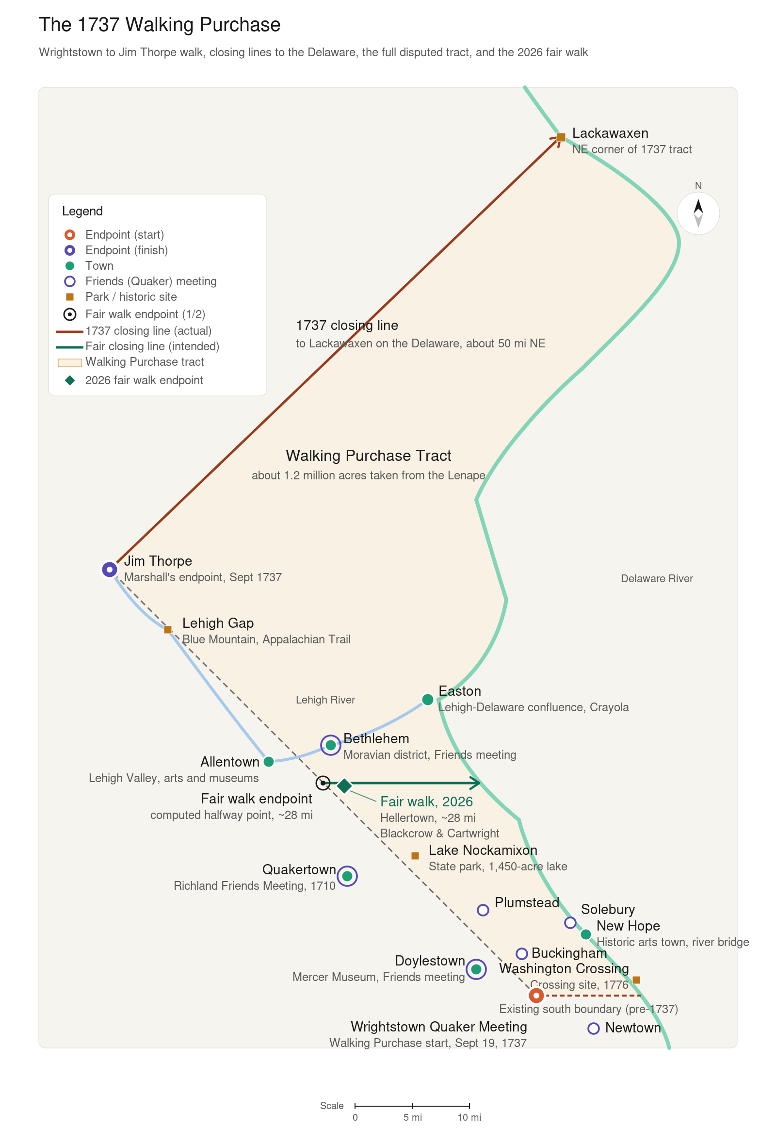
The actual 1737 tract (red wedge) compared with the fair tract (teal line). The fair tract is about one-seventh the size of what was actually taken. The teal diamond marks where the 2026 fair walk ended.
Tested on foot, 2026
On September 19, 2026, a small group of Native Americans led by Eugene Blackcrow and Bart Standing Elk Cartwright set out to walk the approximate route of the 1737 walk the way the Lenape had understood it: at an ordinary walking pace, for a day and a half. They stopped at 1770 Meadows Road in Lower Saucon Township, just outside Hellertown, about 28 miles in a straight line from the Wrightstown Meetinghouse. That is within two miles of the halfway point this map uses as the fair endpoint. Walked honestly, a day and a half reaches the southern edge of the Lehigh Valley, short of the Lehigh River at Bethlehem, not the Lehigh Gorge beyond Blue Mountain.
About seven times what was understood
The actual 1737 purchase is somewhere between seven and eight times the size of any honest day-and-a-half walk. Said the other way around, the Penns and their surveyors took in something on the order of seven times as much land as the Lenape understood the deal to convey.
The Lenape were displaced from all of it
When the Lenape refused to leave the new tract, the Penns’ provincial secretary James Logan invoked an existing political relationship with the Iroquois Confederacy — to whom the Lenape were nominally subject — and asked the Iroquois to compel them. The Iroquois did. The Lenape were displaced from the entire tract. Many resettled in the Wyoming Valley along the upper Susquehanna and were displaced again from there; eventually the survivors moved west, and most of their descendants today live in Oklahoma and in Ontario.